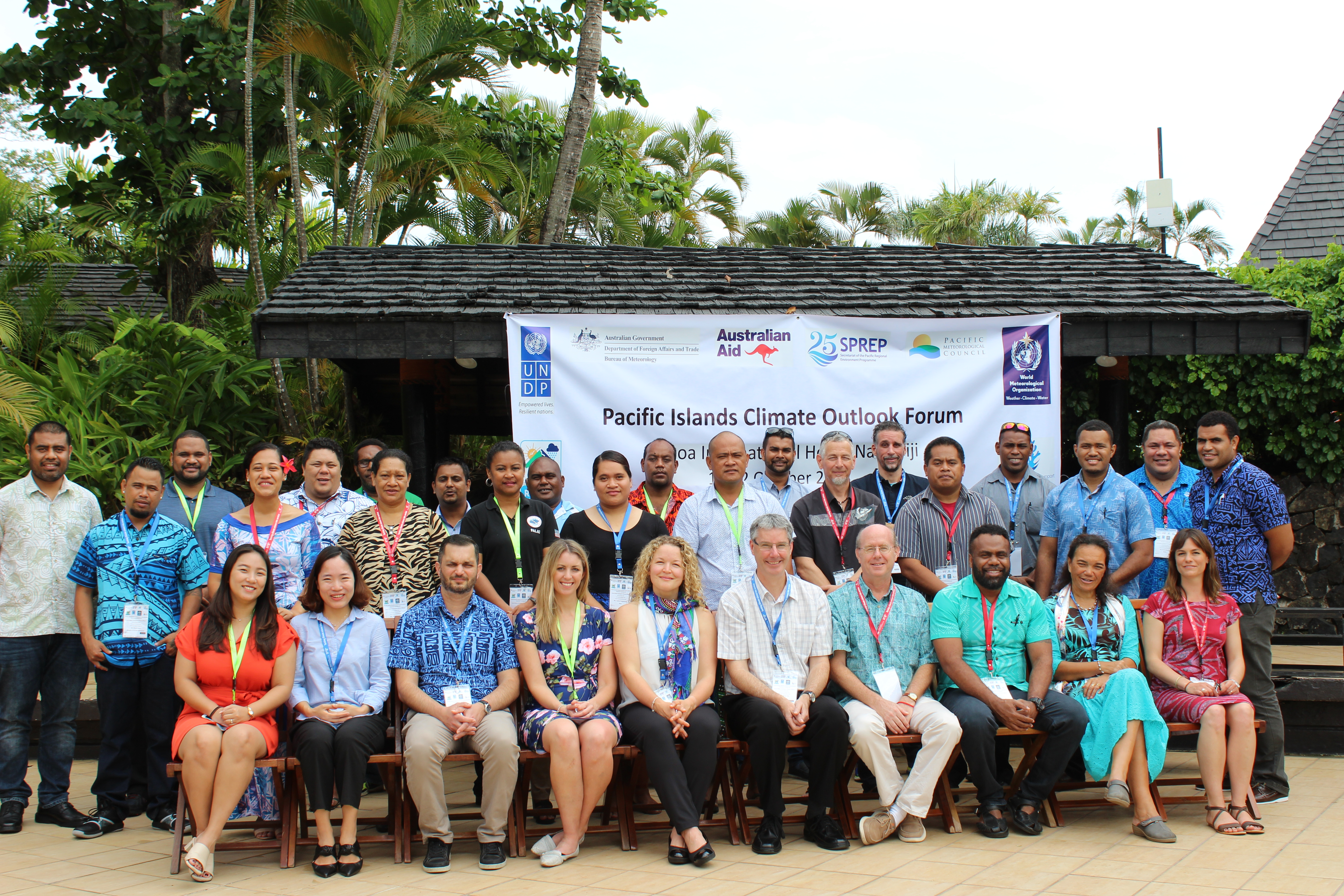
Fourth Pacific Islands Climate Outlook Forum (PICOF-4)
PICOF-4 was held at Tanoa International Hotel, Nadi, Fiji 10-12 October 2018. The forum brought together national, regional and international experts from the Climate Science and Services sectors.
The aim of a Pacific Islands Climate Outlook Forum is to provide a platform to consolidate seasonal forecasts from multiple sources by issuing a consensus regional outlook statement. This process allows its participants to better understand the science behind seasonal forecasts and to better appreciate the related uncertainties that are relevant for the measures applied to adapting and reducing risks to climate variations.
Objectives
The objectives of PICOF-4 were:
- To discuss the 2018/19 Climate and Tropical Cyclone Outlook for the Pacific Islands;
- To compare the various seasonal climate forecast guidance for the Pacific region and discuss how these are produced in terms of accuracy, utility, weaknesses and strengths;
- To discuss how NMHSs are currently accessing and assessing the available guidance, making them nationally-relevant, tailoring them for specific end users, and disseminating them to users; and
- To discuss the Regional Climate Centre (RCC) website.
PICOF-4 was followed by a social media training. The themes for the two days of PICOF-4 were 'looking back and learning' and 'looking ahead and preparing'. Participants on both days included national representatives from the media sector.
Consensus Regional Statement
Regional Statement on the Climate of 2017/18 and Climate and Tropical Cyclone Outlook for the Pacific Islands
Key Messages:
Climate in late 2017 and early-mid 2018
- The year (2018) began with a weak La Niña event which persisted until mid-March. This was followed by neutral El Niño-Southern Oscillation (ENSO) conditions;
- In recent months, the central and eastern equatorial Pacific ocean has warmed, but warming has not yet exceeded El Niño thresholds. An El Niño Watch was issued in mid-June. This has since been upgraded in the last week to an El Niño Alert (Watch and Alert defined at http://www.bom.gov.au/climate/enso/outlook/#tabs=Criteria
- Seven tropical cyclones formed in the November to April 2017-18 Southwest Pacific tropical cyclone season. This is broadly consistent with cyclone outlooks that were issued for the 2017-18 season. The long-term average number of cyclones for the Southwest Pacific is ten.
Climate, Ocean and Tropical Cyclone Outlooks October to December 2018
- There is approximately a 70% chance of El Niño being declared before the end of 2018;
- Irrespective of El Niño-like thresholds being reached or sustained, near El Niño conditions are likely to affect most of the Pacific with resulting impacts on rainfall and air and sea surface temperatures;
- Below normal rainfall is forecast for countries in the region extending south-eastward from Tokelau to northern French Polynesia and some countries in the western tropical north Pacific. With less confidence, near normal or below normal rainfall is forecast for Vanuatu, Fiji and Tonga. Near normal or above normal rainfall is forecast for Guam, the Commonwealth of the Northern Marianas Islands (CNMI), and much of the Marshall Islands and, with less confidence, Samoa, Tuvalu and Kiribati.
- Air and sea surface temperatures are likely to be above normal for much of the tropical Pacific region;
- Above normal sea surface temperatures capable of causing coral bleaching and mortality are favoured for much of the central equatorial Pacific;
- Sea level is likely to be higher than normal in the central and eastern equatorial Pacific;
- Above average tropical cyclone activity is expected in the western North Pacific in 2018;
- For the Southwest Pacific region as a whole, near average cyclone numbers are favoured for the November to April 2018/19 Tropical Cyclone season. Tropical cyclone activity is expected to be lower than normal around the northern and eastern Coral Sea margin and elevated east of the International Date Line.
Review of 2017-18 climate:
In late October 2017, several international climate models favoured a weak La Niña developing towards the end of 2017. The La Niña event developed in early December with the event continuing until mid-March 2018. Associated with the La Niña was generally above normal rainfall in the western tropical Pacific and below normal rainfall in the central Pacific (Nauru, Kiribati, Tuvalu and the northern Cook Islands). Drought was experienced in the northern Cook Islands and eastern Kiribati.
More recently, El Niño-like conditions have developed, with an El Niño Watch issued in mid-June and an El Niño Alert issued in early October. Associated with these El Niño-like conditions were weaker than normal trade winds in the equatorial Pacific, higher than normal sea level and warmer than normal ocean surface temperatures in the central Pacific. The latter has resulted in coral bleaching alerts being issued around Nauru and western Kiribati.
Abundant rainfall was received throughout most of the United States-Affiliated Pacific Islands (USAPI) during the first half of 2018, with almost all recording stations reporting above normal rainfall for the first half of the year. Most recently Palau, parts of FSM, Marshall Islands and several countries in the southwest Pacific have experienced drier than average conditions. As of the end of September 2018 severe rainfall deficiencies conditions existed in parts of FSM, Marshall Islands and Fiji.
Seven tropical cyclones formed in the November to April 2017-18 Southwest Pacific tropical cyclone season. This is broadly consistent with cyclone outlooks that were issued for the 2017-18 season. The long-term average number of cyclones for the Southwest Pacific is ten. Western North Pacific tropical cyclone activity has been higher than normal to date in 2018. Twenty-one storms have been named. Eight above the long-term average of 13.
El Niño Southern Oscillation (ENSO) outlook:
The ENSO Outlook was raised to an El Niño Alert on 9 October. This means there is approximately a 70% chance of El Niño occurring in 2018 - around triple the normal likelihood.
The tropical Pacific Ocean has warmed in recent weeks, particularly in the central Pacific, due to weakening of the trade winds, while the Southern Oscillation Index has fallen to typical El Niño levels. Models suggest further warming of the Pacific is likely the coming months. A majority of global ENSO models predict El Niño thresholds will likely be exceeded in the coming months. The US National Weather Service predicts the event to peak between December and February with the event ending around March 2019.
Climate and Ocean outlooks for October-December 2018:
Given the likely location of the maximum ocean surface anomalies in the central Pacific, the typical impacts associated with a more traditional, canonical El Niño (where maximum warming is located in the eastern tropical Pacific) are not expected. As a result, rainfall outlooks are associated with lower confidence for some locations.
Based on the most recent guidance available, below normal rainfall is forecast for the region extending south-eastward from Tokelau to northern French Polynesia, including the northern Cook Islands, the Tuamotu archipelago and the Marquesas. Below normal rainfall is also favoured for the Federated States of Micronesia and Palau region in the north tropical Pacific. With less confidence, near or below normal rainfall is forecast for Vanuatu, Fiji and Tonga. Near or above normal rainfall is forecast for Guam, the CNMI, and much of the Marshall Islands and, with less confidence, Samoa, Tuvalu and Kiribati. For the remainder of the Pacific, near normal rainfall is forecast, but confidence is low.
Air and sea surface temperatures are predicted to be above normal for much of the region, except for the far south-eastern Pacific, towards the eastern fringe of French Polynesia.
For the rest of 2018, heat exposure capable of causing coral bleaching and mortality will continue in the central equatorial Pacific. Coral bleaching alerts are already in place for Nauru and western Kiribati (see map above).
Sea levels are likely to continue to be higher than normal in the central and eastern equatorial Pacific. In the northern tropical Pacific, sea levels are forecast to be below normal.
Tropical Cyclone Outlook:
Above average tropical cyclone activity is expected in the western North Pacific in 2018. Three or four tropical cyclones of tropical storm intensity or higher are likely to pass nearby Guam, the Commonwealth of the Northern Mariana Islands (CNMI), Yap or Palau by the end of this year.
In the Southwest Pacific, regional-scale tropical cyclone outlooks for the upcoming November 2018 to April 2019 season favour near average (7-11) numbers of tropical cyclones, following the very early TC Liua that formed in September. Tropical cyclone activity is expected to be lower than normal around the northern and eastern Coral Sea margin and elevated east of the International Date Line.
Tropical cyclones have a significant impact in the tropical Pacific. In the Southwest Pacific, Vanuatu and New Caledonia typically experience the greatest activity, with an average of two or three named cyclones passing close to land each year.
If conditions change over the coming months then the tropical cyclone outlook will be updated. All communities should remain vigilant and follow forecast information provided by their National Meteorological and Hydrological Service.
Recommendations from PICOF-4:
Regional forums such as the PICOF are important for sharing information, best practices, and lessons learnt. This should continue and be linked to the functions of the Pacific Islands Regional Climate Centre (RCC), as this becomes established.
Close working relationships between Pacific National Meteorological and Hydrological Services (NMHSs) are critical to effective warning of climate hazards leading to early preparedness. All countries throughout the region should continue to strengthen these relationships, as well as with other sectors through such mechanisms as one-on-one discussions, cluster group meetings and national climate outlook forums.
In addition to the production of national seasonal climate outlooks which are well communicated to sectors, there is a need for simplified products and messaging especially for rural and remote communities. Sectoral impacts are most often related to drier or wetter than normal conditions. NMHSs should continue to develop climate products tailored for national sectors, relevant to their needs, and incorporating where possible traditional knowledge elements.
Climate and Tropical Cyclone outlooks for the whole Pacific region should continue to be well communicated to all NMHSs in the region prior to general release, to ensure consistent responses are provided to local media enquiries.
Further Information:
For more country-specific information please contact your local National Meteorological and Hydrological Service.
This statement was produced at the fourth Pacific Islands Climate Outlook Forum (PICOF) held at the Tanoa Hotel, Nadi, Fiji from 10-12 October 2018. The forum had a specific focus on the climate of September 2017 to September 2018, and the regional climate and tropical cyclone outlook for 2018/19. Representatives at the forum were from regional organisations, NMHSs and Red Cross.
PICOF-4 was attended by members from Australia, Cook Islands, Federated State of Micronesia, Fiji, French Polynesia, Kiribati, Marshall Islands, New Caledonia, Nauru, New Zealand, Niue, Palau, Papua New Guinea, Samoa, Solomon Islands, South Korea, Tuvalu, United Kingdom, United States of America and Vanuatu.
Pacific Regional Environment Programme (SPREP), Pacific Community (SPC), International Federation of Red Cross and Red Crescent Societies (IFRC), Australian Bureau of Meteorology (BoM), United States National Oceanic and Atmospheric Administration (NOAA) and New Zealand National Institute of Water and Atmospheric Research (NIWA) and Asia-Pacific Economic Corporation (APEC) Climate Center provided technical support. Financial support was received from the Australian Department of Foreign Affairs and Trade (DFAT) funded Climate and Oceans Support Program in the Pacific (COSPPac), Government of Russia through the United Nations Development Programme Disaster Resilience for Pacific Small Island Developing States (RESPAC) Project, World Meteorological Organization – Climate Risk and Early Warning Systems (CREWS) Project, United Kingdom Met Office and SPREP.
This statement is consistent with the Nuku'alofa Ministerial Declaration for Sustainable Weather and Climate Services for the Resilient Pacific, which recognises the importance of Meteorological and Hydrological Services in support of relevant national needs, including protection of life and property, sustainable development and safeguarding the environment. The same noted that weather and climate services are not an option but are a responsibility and a basic human right.